NatureScot data services
We collect data and information on many aspects of Scotland’s environment. Our online data services let you access this knowledge easily.
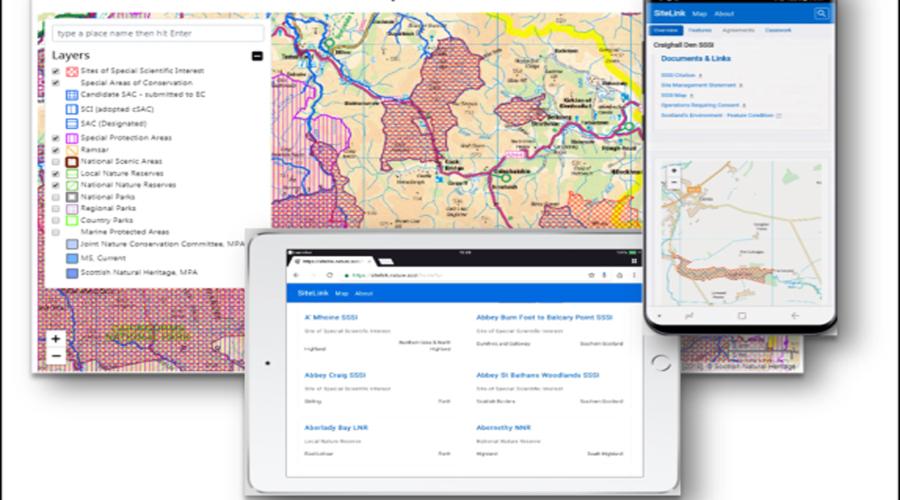
SiteLink
SiteLink has been specially developed to provide access to information on Protected Areas across Scotland.
Find out about sites designated for their natural heritage across Scotland. SiteLink includes:
It also provides access to a wide range of data for designated sites including Site Features, Management Agreements, Site Condition Monitoring details, Boundary maps and other site related documents for download.
Contact: email your user feedback to [email protected]
Open Data Hub
The Open Data Hub provides open access to NatureScot's main spatial datasets as data downloads.
Contact: email your user feedback to [email protected]
Remedies
The Remedies database is a tool used by landowning organisations to manage data relating to features on protected areas.
Contact: email your user feedback to [email protected]
Standing Waters Database
We manage the Standing Waters Database, which includes aquatic plant and other data from more than 3,000 Scottish lochs.
Source the data from more than 3,000 Scottish lochs to find out about their surface area and altitude, aquatic plant life, water chemistry – and more.
Search the database for a specific loch to view survey maps for that loch and to download a list of the aquatic plants recorded there. You can search by site name or using a map.
You can also view the summary Lake Assessment for Conservation (LACON) score on any survey page to better understand the conservation value of the surveyed loch.
Other details provided for each loch include:
- surface area and altitude of the loch
- water chemistry data
- links to designated site information
- a link to the UK Lakes Portal for information on physical and chemical parameters, plus biological data for the lake and its surrounding catchment
The database also holds information for some lakes in England and Wales.
Contact: email your user feedback to [email protected]
Scotland’s Environment – Get Interactive
Scotland’s Environment brings together in one place a wide range of environmental data published by various Scottish organisations and agencies.
Use Scotland’s Environment interactive Map view tool to search maps that show the status of different aspects of the environment across Scotland.
The Land Information Search tool also lets you search maps for details about a selected area of land. It’s useful if you are applying for a land-based grant or licence, e.g. via the Scottish Rural Development Programme.
NBN Atlas
The NBN Atlas Scotland provides a platform to engage and inform people about the natural world. It aims to help improve biodiversity knowledge, open up research possibilities and change the way environmental management is carried out.
It combines information about habitats and species from multiple sources - in a single location. Uniquely it allows users to interrogate species records, habitat, climate and soil information, geographical boundaries using mapping tools.
It is also simple to interrogate your own biological records and habitat information, as well as allowing you to download and export maps, reports or summaries for your own use.
Find out more
Last updated: