Guidance for Assessment of Effects on Special Landscape Qualities (AESLQ)
Guidance prepared by NatureScot, the Cairngorms National Park Authority, and Loch Lomond and Trossachs National Park.
Background
This guidance on the Assessment of Effects on Special Landscape Qualities (AESLQ) has been prepared by NatureScot, the Cairngorm National Park Authority (CNPA) and the Loch Lomond and Trossachs National Park Authority (LLTNPA). This guidance applies to SLQs identified for designated National Scenic Areas (NSA) and National Parks in Scotland. These are highly valued areas that represent the country’s finest landscapes, and the importance of their SLQs is reflected in national planning policy.
Purpose
Assessment of effects on ‘special qualities’ or ‘special landscape qualities’ (from this point, referred to as Special Landscape Qualities, SLQs) is carried out where a proposal is within or would affect an NSA or National Park in Scotland. This guidance has been prepared to assist people in three key ways:
- by describing the sequence of steps to follow when carrying out an AESLQ;
- by demonstrating how the SLQs can be used to influence the siting and design of a proposal and potentially provide enhancements;
- and by explaining why and how this information is required to inform judgements on effects in relation to planning and land use policies, ensuring transparency.
National policy strongly supports a design-led approach to managing change in our landscape. Incorporating development or land use proposals sympathetic to designated landscapes requires careful thought and a strong commitment to achieving high-quality design from the outset. AESLQ provides a structure to achieve this.
Introduction
Assessment of effects on ‘special qualities’ or ‘special landscape qualities’ (from this point, referred to as Special Landscape Qualities, SLQs) is carried out where a proposal is within or would affect a National Scenic Area or National Park in Scotland. This guidance has been prepared to assist people in three key ways:
- by describing the sequence of steps to follow when carrying out an AESLQs;
- by demonstrating how the SLQs can be used to influence the siting and design of a proposal;
- and by explaining why and how this information is required to inform judgements on effects in relation to planning and land use policies, ensuring transparency.
There is a multifaceted range of issues that may need to be addressed by an AESLQ. This reflects the wide variety of SLQs that occur within the different NSAs and NPs and the different types and scales of development or land use change that may be proposed. An AESLQ will also input different decision-making processes, for example, Town and Country Planning, woodland creation applications, energy consents or various grant schemes.
National Planning Framework 4 (NPF4) strongly supports a design-led approach to managing change in our landscape. Incorporating development or land use proposals sympathetic to these exceptional landscapes requires careful thought and a strong commitment to achieving high quality design from the outset. AESLQ provides a structure to achieve this.
This guidance is currently in draft status, after incorporating feedback from representative landscape practitioners. We encourage use of this guidance prior to its formal adoption and publication. During this interim period, the document should be referenced as: Guidance for AESLQ – Consultative Draft.
Special Landscape Qualities (SLQ)
SLQs are defined as the characteristics that make a designated landscape special in terms of landscape and scenery, both individually or combined (SNH, 2008). They are qualities that are perceived and experienced by people, affecting the sense of place.
In Scotland, we have two national landscape designations: National Parks (currently 2 in number) and NSAs (40 in number). These are highly valued areas that represent the country’s finest landscapes, and the importance of their SLQs is reflected in national planning policies and NP policies (see additional information in References). Landscapes are not static and will continue to evolve, but this change needs to be managed carefully to ensure the SLQs are safeguarded and enhanced so they can be enjoyed by future generations.
Reports detailing the SLQs for each of the NSAs and both the Cairngorms and the Loch Lomond and The Trossachs NPs were published in 2010 (see References). The reports vary in their detail, and some describe SLQs generically across the area whilst others distinguish SLQs geographically. All the SLQs identified and described within the reports are equally important.
Within National Parks, any NSA SLQs are subsumed within the National Park SLQs and thus assessment should be for the National Park SLQs.
Using this guidance
This technical guidance describes the approach to take when designing and assessing the effects of a proposed development or other land use change upon the SLQs of a National Park or NSA. In this context a working knowledge of SLQs and other landscape assessment methodologies is beneficial.
The objectives of designation is the safeguard, conservation and enhancement of the interests for which the area is designated (for NSAs this is their special qualities and character; for National Parks this is a broader range of natural and cultural heritage interests).
Overall integrity means the wholeness of the area, the unity or soundness of the whole being unimpaired. Adverse effects even to a part of the designation could be damaging to the unity or soundness of the whole
The alternative policy test of social or economic national benefits clearly outweighing the designation’s interest is for Scottish Ministers to determine.
The test for the need to carry out an AESLQ is whether a proposal is likely to result in significant adverse effects on one or more SLQs within a NSA/National Park (regardless of whether the proposal is within or outside the boundary of the NSA/National Park). If you are unsure, you can discuss this with the relevant decision-making authority and/or consultee. Some initial assessment of the SLQs may be required to assist this decision.
AESLQ will usually be carried out by a Chartered Landscape Architect, although other suitably qualified and experienced landscape, planning or other environmental professional(s) may be able to undertake the process. The findings of the assessment will inform the advice of those evaluating a proposal such as NatureScot, a National Park Authority (NPA) and Planning Authorities.
AESLQ assesses the effects on the special landscape qualities of the nationally designated landscapes of NSAs and NP’s. Landscape and Visual Impact Assessment (LVIA) assesses the effects on landscape character and visual amenity. AESLQ can be informed by and complements other established processes for designing, enhancing and assessing the landscape and visual effects of a proposal, as shown in Figure 1. It is important that the findings of these different assessment processes complement and do not duplicate each other (which could lead to a double-counting of some effects).
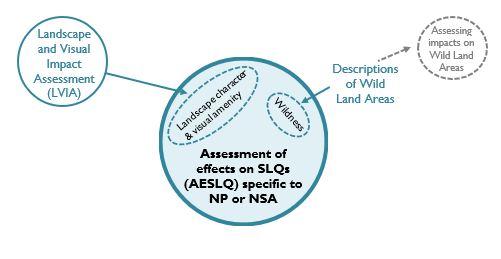
Figure 1: How AESLQ relates to other landscape and visual assessment processes.
Click for a full description
Bubble Diagram showing how AESLQ combines aspects from the LVIA and Wild Land Areas description to draw out landscape characteristics, visual amenity and wildness where they are reflected within the SLQ’s to be assessed within the AESLQ.
An AESLQ is likely to draw on baseline information that forms part of a landscape/ seascape character assessment, LVIA or WLA descriptions but it should not duplicate information within any of these. This is because it specifically concerns the SLQs of a National Park or NSA, not the wider range of landscape and visual sensitivities and effects that may be affected by a proposal. AESLQ may also be a stand-alone assessment when other assessments are not required.
All NPs and NSAs are recognised by their designation as being of high value. In this context, the assessment should focus on the specific aspects of SLQs which are susceptible to change and for which it is possible to site and design proposals to directly respond and enhance the SLQs.
The detail required for an AESLQ will differ according to circumstances, including amongst other things the nature and scale of the proposal. AESLQ should be tailored to reflect the location, scale and type of a proposal and the potential significance of effects arising. Consultation with the relevant decision-making authority and/or consultees especially during the early stages of an assessment (at pre-app and scoping) is encouraged as the assessment determining whether integrity has been compromised is not dependant on an extensive area or large number of SLQ’s being significantly affected. Topics to discuss and agree can include whether an AESLQ is necessary (and, if so, how it relates to other assessment methodologies), design objectives relevant to the SLQs, scoping of SLQs for assessment, definition of the study area and choice of assessment viewpoints.
The Assessment Process
Once the need for an AESLQ has been established and consideration has been given to its relationship with other assessment processes, the following section sets out four steps to follow to complete an AESLQ. The findings of this assessment can be reported in a template as included in Annex 1.
The process has four steps;
Step 1 – The Proposal
Step 2 – The Scope of the AESLQ and Baseline Conditions
Step 3 – Assessment of effects on SLQ’s
Step 4 – Summary of significant effect on SLQ’s
The assessment should;
- focus on likely significant effects on SLQs;
- be proportionate to the scale and nature of the proposal;
- be focussed, proportionate and transparent so the reasoning which informs judgements can be understood; and
- convey the relationships between effects and how these would be experienced by people.
Step 1 - The Proposal
To inform the AESLQ, it is first necessary to understand the nature of the proposed development or landscape change. Where possible, specific reference should be made to the project description within the application, Environmental Impact Assessment Report, LVIA or related documents to avoid duplication of material, drawing-out and summarising just the key components relevant to the SLQ assessment.
Components to consider include the requirements and potential design of the proposal as well as its location and siting, for example its scale and extent, colours, and materials. It is only by gaining a thorough understanding of the proposal that the full effects on the SLQs will be able to be assessed in Step 4, as well as the scope for design, mitigation and enhancement options during the intervening steps.
Step 2 - Scope of the AESLQ and Baseline Conditions
Define the study area, establish baseline conditions and assess susceptibility to the proposal. This is a key stage of the AESLQ and covers two distinct tasks: first, to establish the scope of the assessment and the extent of the study area; and second, to establish the specific SLQ baseline conditions and susceptibility of these to the proposal. These tasks will be informed by:
- The landscape and seascape characteristics (informed by Scottish Landscape Character Assessment, and Coastal Character Assessment and local landscape/ seascape character assessments where available) and visual amenity which underpin the SLQs;
- Wildness attributes and SLQs, informed by wildness mapping and WLA descriptions where available;
- The predicted extent and distribution of visibility of the proposal (which may be informed by a Zone of Theoretical Visibility (ZTV) map); and
- An understanding of how the SLQs are expressed and experienced from different parts of the NSA/NP, individual and combined SLQs, and the experience of SLQs such as from distinct routes, whilst moving through the landscape, and from key locations.
Whilst some of the information required for AESLQ can be obtained from a desk study review of existing data, site visits are essential to provide both a robust level of baseline data on the nature and extent of SLQs, and the assessment of predicted effects on these. SLQs also need to be assessed on site to fully understand how individual or groups of SLQs come together and are experienced in a specific area. This means, for example, an initial study area and range of possible SLQs might be identified through desk study and then be refined following a site visit.
The study area for the AESLQ should relate to the location and type of the proposal and an initial prediction of likely significant effects and should be defined, field-tested, and agreed in consultation with the relevant decision-making authority and/or consultee. The study area may be a part, or the whole of the NSA or NP, but won’t extend beyond the designated boundary.
Where a proposal is located outside or crosses a NSA or NP boundary, the study area of an AESLQ will only extend to the boundary of the NSA or NP. However, the assessment must consider the contribution of the landscape beyond the boundary, where it influences the experience of the SLQs. This aspect is illustrated in the diagrams below.
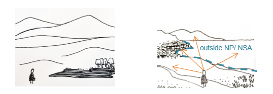
Figure 2: Although the assessment of effects on SLQs occurs within the NP or NSA, the SLQs may be influenced by landscape features outside the NP or NSA.
Click for a full description
Sketches showing how while the assessment of effects on SLQ’s occurs within the National Park or NSA, the SLQs may be influenced by landscape features outside of these areas.
The study area for an AESLQ may be informed by, or tangibly different to the study area for an LVIA for the same proposal. This is because the AESLQ relates specifically to the SLQs within a NP or NSA and how these are experienced, and not the wider landscape characteristics or visual amenity.
To identify which SLQs are likely to be significantly affected by the proposal, information should be gathered and reviewed as follows:
SLQs should be considered in relation to the site location and the proposal, and informed by fieldwork, map data and discussion with consultees as appropriate.
Identify and review the key landscape, seascape characteristics, visual amenity and wildness attributes within the AESLQ study area. Although some of this information may be available in published reports, additional information is likely to need to be gathered through site assessment to provide a full understanding of the SLQs most relevant to the proposal. It is emphasised that, when referring to landscape character, it is the key landscape characteristics that need to be drawn out in relation to SLQs, not individual landscape character types or areas (which would be assessed as part of a LVIA).
For proposals beyond the boundary of the NP or NSA, the intervening landscape will also need to form part of the on-site assessment. Aspects to consider include whether key landscape characteristics are contiguous across the boundary of the NP or NSA, or does the boundary define a change in landscape character? This assessment also needs to consider the visual relationship between the site and AESLQ study area.
Some SLQs may have a definite physical location, such as a ‘named’ view or a built structure or settlement, whereas others incorporate greater perceptual responses, including timelessness and spirituality. Other SLQs recur and are experienced together, such as mature pine woods within an incised glen. Understanding where people go and how people move through and experience SLQs is crucial to the assessment.
SLQs can be considered individually or grouped. Where the SLQs interact with each other, contributing to the experience of these within the study area, they are best assessed and reported together as a group. A brief justification for why SLQs are grouped should be reported in the AESLQ. For example, an SLQ which recognises mature specimen trees may also contribute to wider diversity and rich mosaic of a farmland SLQ along a strath and so could be combined.
To assess the experience of SLQs, fieldwork for AESLQ should include survey from carefully selected sample points which represent the range of locations from where the SLQs are experienced that are likely to be affected by the proposal. Locations could include, for example: from hill tops and landmarks; along linear, circular and criss-crossing routes through a landscape; along glens or the coast; or across a river or watershed. Some LVIA representative viewpoints may be suitable to double-up for SLQ assessment but they will not necessarily represent the best locations to assess SLQs (for example, because of being selected for their extent of visibility rather than experience of distinct SLQs). Thus there may be a need to provide supplementary assessment points chosen to reflect the experience of the SLQs, which may require visuals (such as wirelines) to inform the assessment.
The range of people (termed ‘receptors’ in LVIA) who will experience the effects on SLQs should be considered in the choice of sample viewpoints for survey and formal assessment. In terms of the susceptibility of the receptor to change this may influence the overall assessment of effect, depending on the type of receptor and context of view. However the numbers of receptors, whilst useful to record, does not in itself, directly inform this assessment of susceptibility, as different landscapes attract a varying number of people to experience different SLQs. The less frequented destinations can experience the same level of susceptibility to change on the SLQs as the more heavily frequented destinations.
Summary of baseline SLQs
Template column A: Identify key SLQs and their susceptibility to proposal
At the end of Step 2, after analysis and review of the SLQ baseline conditions, only those SLQs which are considered to be susceptible to the proposal and are likely to be significantly affected by it are taken forward to the next stage of assessment (Step 3). This is so the scope of the AESLQ is proportionate and focuses on what is most important. Once these SLQs have been identified, both individually or grouped, these should be summarised within column A of the AESLQ template (Appendix I).
Assigning levels of susceptibility to the proposal for example low, medium or high, are required to understand how the intrinsic elements and experience of the SLQs may be affected in relation to the specific nature and components of the proposed development or land use change. The basis for these judgements must be clear and linked back to evidence developed during the baseline study.
Step 3 - Assessment of effects on SLQs
This section of the guidance describes the process for ‘up front’ design, enhancements and mitigation of the potential effects of a proposal to relate to the SLQs and, in turn, assessing residual effects. Although the assessment steps (and template columns) suggest a linear sequence, the process of assessment is iterative. It is expected that the assessor will move back and forth through the steps, considering design alternatives, potential effects, mitigation to reduce effects, further design options, and so on until a solution is found which enhances and relates best to the SLQ and minimises adverse effects on these.
Design
Template column B: Develop design objectives in direct response to SLQ susceptibilities to proposal (including management practices) and input into design of proposal
- Developing SLQ design objectives provides the basis for proposals to maximise positive effects on SLQs and minimise negative effects, within the constraints of the proposal, helping people to conserve and enhance the SLQs. They can also influence landscape maintenance and monitoring, providing a baseline of intent against which proposals can be compared. This may be particularly useful when proposals and schemes are modified or extended over long timescales. There can be multiple potential design options for any specific proposal. In recognising this (and taking on board other constraints) it might not be possible to satisfy every design objective. Nonetheless, establishing clear design and enhancement objectives provides the basis upon which options can be reviewed methodically.
- The AESLQ will assist this process so design objectives can directly respond to and enhance the individual and combined SLQs (building upon but not duplicating the objectives identified as part of an LVIA if being undertaken). The recording of this process also helps people to understand the approach and reasoning for the final design proposal, including the relative balance of SLQ design and enhancement objectives together with other project objectives.
- For each SLQ (individual or grouped) identified in column A, this stage involves identifying a design objective in column B. This needs to take into account the requirements of the proposed development or land use change (Step 1). The design measures considered should include management practices and potential effects over time.
- Some examples of design objectives developed in direct response to SLQs are shown in Table 1 below.
|
SLQ |
Example design objective |
|---|---|
|
Views along distinct glens, their landscape pattern emphasised and space contained by simple backdrop of adjacent hills |
The proposal should be within either the glens or backdrop hills but should avoid spreading across both and thus eroding the distinction between these |
|
Enclosure, intricacy, diversity and distinct pattern of light within native woodland |
Ensure design (extent, density and species) and tailored management of new woodland reflects SLQ of existing woodland even if slightly different in some aspects, eg species |
|
The spatial containment of local hills and/ or distinctive local buildings create ‘gateway’ features |
The proposal should avoid obscuring or distracting from the gateway features or its scale seeming to diminish the focal importance of this / these |
|
Successive layers of landform horizons seen receding over far distances |
The proposal should not interrupt views over the successive horizons, nor seem to diminish the perceived extent of the landscape by its position or scale in relation to the visible layers |
|
Dark, rural skies |
Lighting should be designed to avoid illumination of dark skies or the creation of point light features that are incongruous or distract from the experience of dark skies |
|
Sequence of SLQs experienced through journeys, e.g. from lowlands to highlands, from developed coast to undeveloped coast, and between settlements and open countryside |
The proposal should reflect distinction of SLQs when travelling through landscape, eg avoiding introduction of unifying feature or characteristic such as roadside development, consistent land cover or repetition that has collective effects such as houses or wind farms |
|
Wildness, displaying an absence of human artefacts |
Reduce the influence of development on the wildness attributes experienced, eg siting the structure closer to settled elements and at lower elevation, also reducing prominence. |
During the iterative process of design and assessment, when potential significant effects on SLQs are identified, mitigation (see glossary for more detail) options should be explored further to avoid or reduce these through location, siting or design.
Assessment of effects, mitigation, and significance
Template column C: Effects of the proposal on SLQs (incorporating primary mitigation)
The assessment at this stage requires consideration of the key components of the proposal and their predicted effects. As for other assessment methodologies such as LVIA, an assessment of the ‘magnitude’ of effects is necessary, including the scale and extent of effects, their reversibility, and their duration. Assigning levels of magnitude of change for example low, medium or high, are helpful to understand where different levels and spatial extents of change are predicted. Where used, a definition for these levels of magnitude should be provided.
As for LVIA, overly quantitative or formulaic approaches are to be avoided because the intention is that AESLQ takes a more descriptive, qualitative approach that focuses on SLQs and their experience. For larger and/or complex proposals, assigning levels of effect is recommended, but this may not be necessary for smaller and/or simpler proposals. The key test is whether assigning levels would add value in terms of understanding the baseline conditions and the nature of effects and, importantly, assist in judging whether residual effects would be significant or not (Column D).
Both landscape character and visual amenity influence SLQs, as described in paragraph 5 above. This means that AESLQ needs to consider both these aspects but, unlike LVIA, these do not need be assessed and reported separately. Conversely, the focus and value of AESLQ is to draw out how landscape and visual aspects combine as SLQs, and how these are experienced and valued by people in a NP or NSA.
ZTVs, visualisations, wireline diagrams and/ or photomontages may inform the assessment of effects on SLQs, especially when analysed on site. In LVIA and AESLQ, ‘visibility’ simply refers to something being seen. Being visible, doesn’t necessarily mean that a landscape change will contribute to a notable effect on SLQs; this depends on what can be seen and how this relates to its context and is viewed (visual receptors).
SLQs are influenced by how people experience them. Thus, a proposal may have effects on SLQs without necessarily being seen from a specific place if it is visible from other locations nearby or affects the wider extent of SLQs. For example, the journey along a coastal SLQ may be experienced as a sequence of landscape characteristics and views inland and out to sea defined by the coastal hills along an indented coast. Introducing development onto the coastal hills may only be visible for intermittent periods but, taken as a whole, the development could significantly intrude on the qualities of how this SLQ is experienced as illustrated below.
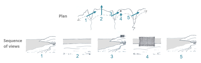
Figure 3: A sequence of views showing how the proposal might effect the experience of the alternate pattern of inlets and coastal hills which are a SLQ in this area, even though the proposal is not visible from everywhere along the coast.
When assessing visibility and effects on SLQs, it is useful to distinguish between the following:
- Visibility of the proposal
- Effects of the proposal which would not affect the SLQs (eg being prominent as an isolated feature but not seeming to affect key SLQs within an area such as views to hill horizons, the link with an adjacent river or perception of tranquillity)
- Landscape and visual effects of the proposal which would affect the SLQs (eg, interrupting views across open moorlands or mountains, or introducing a distraction to a distinct local landmark)
- Landscape and visual effects which would significantly affect the SLQs (ie they don’t just affect the views of people, but change these in a way that would be significant to pre-defined thresholds (eg the introduction of extensive woodland which alters the balance of SLQs experienced).
- Potential cumulative effects with other proposed developments or landscape change over time, for example contributing to incremental effects on SLQs within the NP or NSA.
This distinction highlights the importance of carefully selecting sample locations to assess a representative range of potential effects on SLQs. For this purpose, some sample points may also be LVIA viewpoints, but some LVIA viewpoints may not be best-suited for assessing effects on SLQs as discussed in paragraph 29.
Assessing the combined effect of different individual effects on different SLQs can be a challenging process. Professional judgement is required to consider different influences on SLQs, for example balancing those that are numerous or affect extensive areas with those that occur singularly or affect small areas. The key requirement is for the AESLQ to assess the whole range of SLQs and effects, document these in a methodical and transparent manner, and then assess those that are significant, which may include some that are infrequent or localised as well as those that are numerous or extensive.
This highlights that simple conclusions on significance cannot be drawn directly from the numbers, proportions, or area of SLQs affected by a proposal, nor maps such as ZTVs overlain on NP or NSA maps.
Similar to the process described above for column B, this stage involves consideration of further mitigation measures (known as secondary measures; see glossary for more details) when potential significant effects on SLQs are identified. This assessment should be reported in a narrative manner to understand the direct link from the information reported in the previous columns A-B-C.
The following questions should frame the consideration of mitigation during Step 3 (columns C)
- Is there potential for mitigation to avoid or reduce predicted adverse significant effects on the SLQ(s) and their experience (as part of the iterative process for example, through re-siting, design modifications or management)?
- What are realistic timescales for mitigation to become effective in reducing effects on SLQ(s) (for example length of time for native woodland to achieve maturity and restoration of land cover disturbance)? What is the certainty that mitigation will become effective?
- Is there potential for enhancement that benefits SLQs?
Column D Significance of residual effects on SLQs (including all mitigation and reflecting high value of designation)
This stage involves final assessment of effects on SLQs after all mitigation and enhancement measures have been incorporated. This is based on:
- The susceptibility of the SLQ(s)
- The ‘magnitude’ of effects
- Predicted residual effects on the SLQ(s) once all mitigation is incorporated in the proposal.
When determining significance, it is highlighted that this must also recognise the high value of all NSA and National Park designated landscapes.
Having considered the factors described above, an assessment of overall significance of residual effects (after mitigation) on the SLQs or group(s) of SLQs can be made. When carrying out this assessment, it may be useful to consider how the proposal meets the design objectives (Column B).
It may also be useful to distinguish levels of effect, such as high, medium, low or negligible, with medium or higher effects generally considered ‘significant’ for the purposes of applying policy tests. For transparency, all measures of effect need to be defined with direct reference to the SLQs, and the consequences on these such as their enhancement, removal, erosion, change or retention.
Step 4 - Summary of significant effects on SLQs (individual and grouped)
This step draws together all the strands of the AESLQ to present a summary of predicted significant residual effects on individual and grouped SLQs, including the distribution of effects within the study area and their significance. This will provide evidence to inform judgements made by decision-makers for example in informing understanding of policy 4c. This step needs not be lengthy and should not repeat information provided elsewhere but should cover the following issues as relevant:
- Identification of the SLQs within the study area for which likely significant effects have been assessed, both individual and/or grouped;
- The nature and levels of effects on relevant SLQs within the study area.
- The location, extent and distribution of effects on the SLQs within the study area, for example whether these are localised, extensive, isolated or repeated within the study area landscape. This should consider the relationship between affected SLQs and the intervening landscape (whether within or beyond the NP or NSA boundary) as well as specific locational issues regarding the way the landscape is experienced, for example gateway experiences, sequential experiences along ridgelines, or specific features or views. It should also consider different effects during day and night and alternative seasons. Assessing extent and distribution of effects is not simply about the percentage of the study area affected but, alternatively, the influence of the extent and distribution of effects on how the SLQs within the study area are experienced.
- The nature, level, location, extent and pattern of effects on the SLQs in relation to: study area, extent of the SLQ (which may be mapped) and the wider NP or NSA. If the study area does not extend across the whole NSA or NP, drawing on the analysis in Steps 2 and 3, it is necessary to consider how the effects within the study area will affect the wider NSA or NP. (For example, even one occurrence of a significant effect on one or more SLQs could influence the quality of a NSA or NP). If a proposal lies outside an NSA or NP, the distance of this from the boundary will be a useful consideration but this should not be used as a proxy for the predicted magnitude of change or significance of effects, as it is the effects on the SLQs and where these qualities are experienced that are important.
- Who will experience the effects on the SLQs and how. The range of people who will experience effects on SLQs should be considered (although the significance of effects will not directly correspond with their number, as this will be influenced by the value of the resource and the SLQs’ susceptibility to change).
- How the final proposal meets the design objectives (column B) and minimises adverse effects on the SLQs through design and mitigation measures.
- Potential cumulative effects with other proposed developments or landscape change over time, for example contributing to incremental effects on SLQs within the NP or NSA.
Consideration of AESLQ findings
Once the AESLQ has been completed, the relevant decision-making authority and/or consultee will review the assessed effects on SLQs in relation to the NSA or NP and its integrity. This analysis is used to inform their judgement on whether a proposal would meet or be contrary to relevant policy tests, including those set out at a national level and the National Park Partnership Plans (NPPP).
Assessment of whether ‘integrity’ has been ‘compromised’ requires consideration of the nature of the locations affected and the nature of their qualities. For this assessment, compromise is taken to mean where significant effects result in an evident and noticeable material change to any of the NP or NSA’s SLQs. For integrity to be compromised, this does not depend on an extensive area or large number of SLQs being significantly affected.
Appendices
Abbreviations and Keywords
Assessing the effects on Special Landscape Qualities (AESLQ)
Cairngorm National Park Authority (CNPA)
Landscape and Visual Impact Assessment (LVIA)
Loch Lomond and Trossachs National Park Authority (LLTNPA)
National Scenic Areas (NSA)
National Parks (NP’s)
National Park Partnership Plan (NPPP)
Special Landscape Qualities (SLQ)
Keywords
National Parks (NP’s); National Scenic Areas (NSA’s); Special Landscape Qualities (SLQ’s); Landscape Character Assessment (LCA); Landscape.
Acknowledgements
This guidance has been jointly written by the Cairngorms National Park Authority, Loch Lomond and Trossachs National Park and NatureScot. Particular thanks go to the advisors, consultants and developers who have provided comments on the preceding drafts, have used this guidance and helped shape it in its current form.
References
Council of Europe (2000) European Landscape Convention. European Treaty Series No. 176. Florence, Council of Europe.
Landscape Institute and IEMA (2013) Guidelines for Landscape and Visual Impact Assessment. 3rd edition Abingdon, Routledge.
Scottish Government (2023) National Planning Framework 4. Edinburgh, The Scottish Government.
Scottish Natural Heritage (SNH) (2001) Landscape Policy Framework: Policy Statement No 05/01. Redgorton, Scottish Natural Heritage.
Scottish Natural Heritage (SNH) (2002) Wildness in Scotland’s Countryside: A Policy Statement. Redgorton, Scottish Natural Heritage.
Scottish Natural Heritage (SNH) (2008) Guidance for identifying the special qualities of
Scotland’s National Scenic Areas. Redgorton, Scottish Natural Heritage.
Scottish Natural Heritage (2020) Assessing impacts on Wild Land Areas – technical guidance [Internet], Scottish Natural Heritage. Assessing impacts on Wild Land Areas - technical guidance
Scottish Natural Heritage and Loch Lomond and The Trossachs National Park Authority (2010). The special landscape qualities of the Loch Lomond and The Trossachs National Park. Scottish Natural Heritage Commissioned Report, No.376 (iBids and Project no 648).